


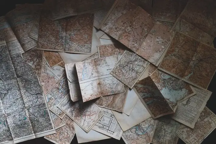
The Journey Back in Time: The Magnificent Art of Cartography in Antiquity


Contrary to popular belief that maps depict places, rivers, and roads, the first maps were actually a representation of the night sky; more precisely, they were visual representations of observations of the night sky made by people. In 1963 in Turkey, a cave painting painted around 6200 BC was discovered in Katal-Hyuk in Anatolia. This painting shows a city with streets, houses, and a volcano.
Show key points
- The earliest maps were visual representations of the night sky rather than depictions of earthly landscapes like rivers or roads.
- A 6200 BC cave painting found in Anatolia, Turkey, might be one of the first attempts at mapping, though its interpretation remains uncertain.
- The oldest known map, created in Babylon around 600 BC, is drawn on a clay tablet and possibly illustrates both mythological and real-world locations.
- ADVERTISEMENT
- Ancient Greek thinkers like Anaximander and Eratosthenes significantly advanced cartography by introducing the concept of a world map and calculating Earth's circumference.
- Early maps often used measurements based on travel time and distances walked, which, combined with triangulation, formed the basis of ancient geographic calculations.
- Ptolemy's map and accompanying book in the second century AD standardized mapping techniques including the use of latitude and longitude still applied today.
- Over time, increased exploration, along with mathematical and astronomical developments, led to progressively more detailed and accurate maps.
Do you call this a cave painting or an attempt at mapping? It remains unclear whether this illustration is a map or just a painting, although several scientists have tried to decipher the mystery. But that means that we as a species were keen to represent what we saw, which I think prompted us to map.
Recommend
What is the oldest known map?
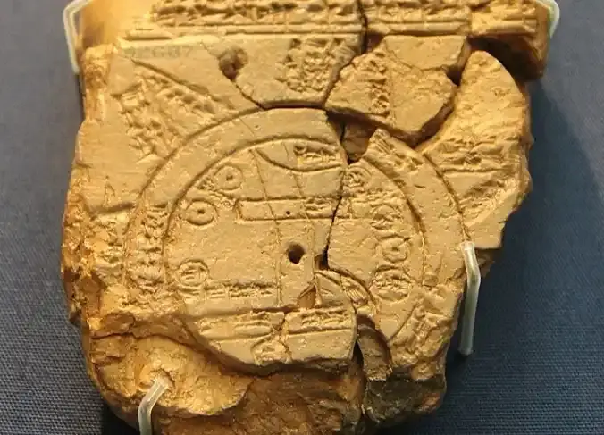
The first known map is from Babylon and was drawn in 600 BC on a clay tablet. It represents the interpretation of the world known to man at that time. There is multiple speculations about the map. Some believe that the map was intended to represent the mythological places believed in by the Babylonians.
Others believe that the map actually represents the ancient world, as this map uniquely illustrates the land beyond the oceans, unlike other maps of the period, which focus only on where it was drawn. It is also believed that the map was a way to determine how surplus agricultural production was directed.
The actual purpose behind the map is still disputed, but the map gives us an interesting view because it accurately represents nearby cities and terrain!
The development of mapping techniques
In the old days, maps were mostly just a pictorial representation of a single place. Like the 600 BC map drawn by the Babylonians, most maps were of a single place, its topography, roads and nearby cities. These maps were created with a mixture of available information from travelers' accounts, scientific hypotheses, literature, and reports of navigators.
Anaximander: Senior Cartographer
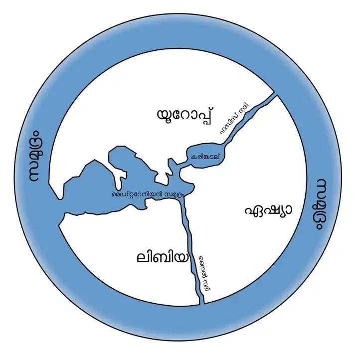
The world map appeared only in the V century. Anaximander, the first cartographer to represent the world at the time. The original map did not survive, but from Herodotus' description, it was a circular map where the land was surrounded by a body of water.
Inhabited Greece was at the center, along with the Mediterranean. The northern part was Europe and South Asia past. It wasn't something very specific, but it's still impressive!
From that moment on, maps became more detailed as more and more areas were explored and written about in maps. These maps still follow the same pattern in being circular, surrounded by the sea on all sides, but these maps contained more detail about places in Asia and Europe.
The cartography was not limited to the Greeks; the Chinese also made maps on silk and wooden blocks dating back to the fourth century.
In the third century, Eratosthenes succeeded in calculating the circumference of the Earth, and proved that the Earth is in fact spherical rather than flat. This discovery also led to subsequent changes in the field of cartography.
The Greeks used the pitch as a measure of distance and it was common to employ pimatians, people who calculate the distance between two places by walking distance. The time it takes people to move between places was used as a measure of distance. All this data gradually helped people figure out the size and distance of certain places.
Triangulation: a mathematical technique for measuring distances
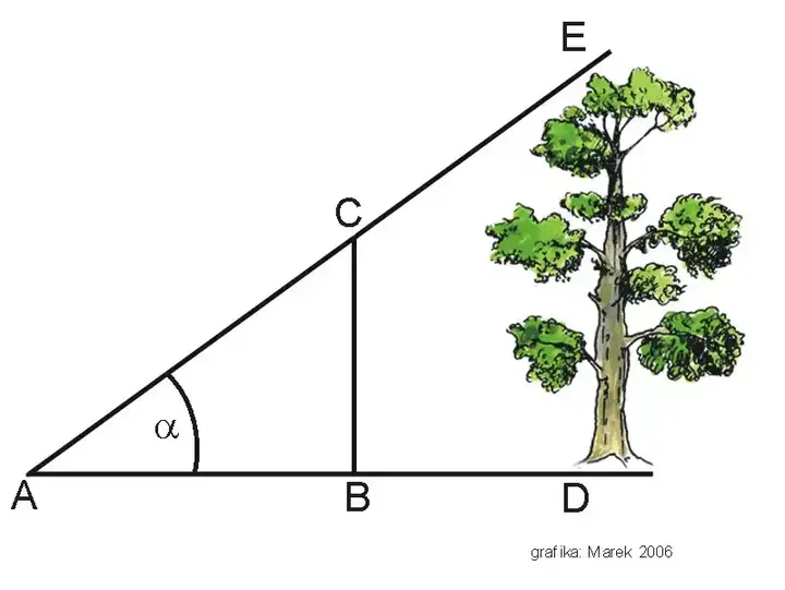
You might be surprised to say that cartography was more related to mathematics than geography in ancient times, but it's true. Mapping was essentially an art that used mathematical methods such as triangulation! If angles and distances between places were known, the distance between them could be calculated; this was the most commonly used technique during those times. This triangulation method is still used today, but in a much more complex way.
Map of Eratosthenes
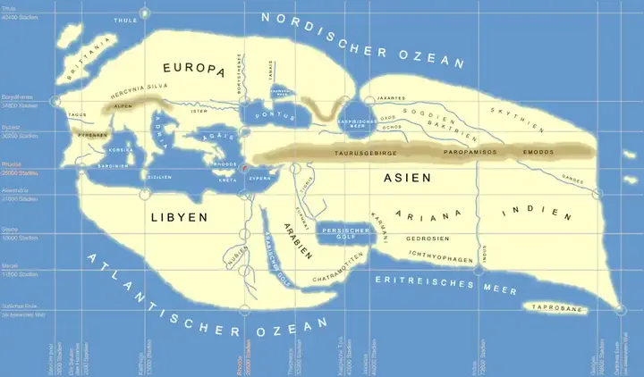
Eratosthenes also developed a network that helped him locate. He designated a line passing through Rhodes and the pillars of Hercules (present-day Gibraltar) as one of the main lines of his network. This line divides the world into two fairly equal parts and defines the longest known stretch between East and West.
He chose a line through Rhodes to be the main hub of the network lines between North and South. He then drew seven parallel lines for both main axes, which formed a rectangular grid. With the help of this network he was able to locate places on the first world map!
Map of Ptolemy
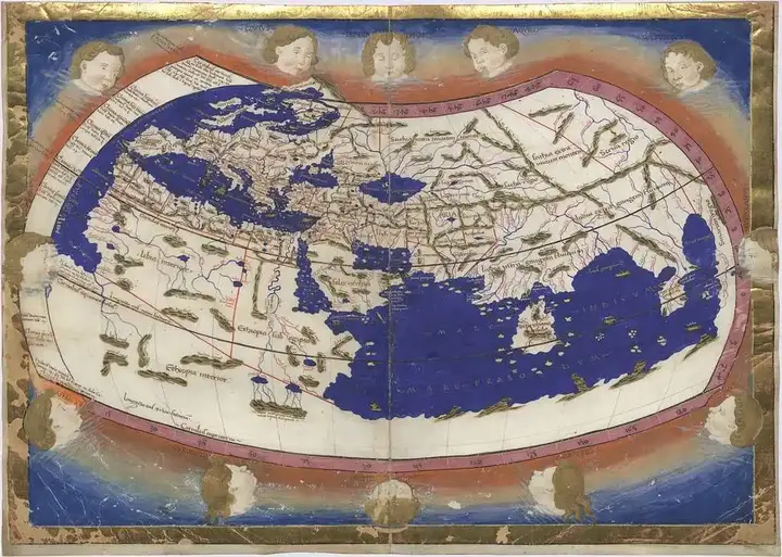
Ptolemy created a map of the world in the second century AD using the latitude and latitude we still use today. Ptolemy's work is similar to the map of Eratosthenes, but his work is more known, since he not only made a map, but also wrote a book on how to draw a map.
His work is based on the work of his predecessors, but his book on geography is exceptional because he explained the gradual procedure of mapping so that people could replicate the mapping technique anywhere. His book was later translated and helped the Arabs copy his map and add details to the world map.
Maps are gradually becoming more detailed as new areas are explored and written on paper. Mathematical and astronomical progress has also helped improve the world map to what we know and love today!
