Why Does Mount Rainier Worry Scientists More Than Any Other American Volcano?

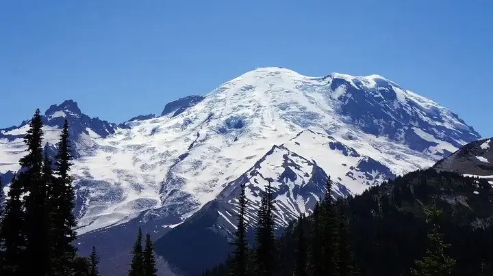
The snow-covered summit of Mount Rainier, rising 4.3 kilometers (2.7 miles) above sea level in Washington State, hasn’t produced a significant volcanic eruption in the past thousand years. However, more than the explosive lava fields of Hawaii or the vast sprawling volcano of Yellowstone, Mount Rainier is what worries many United States volcanologists.
Show key points
- Mount Rainier hasn't experienced a major volcanic eruption in over a thousand years, yet it remains a potential threat due to the complex geology surrounding it.
- Lahars, a muddy combination of rocks and water caused by melting ice, present the greatest threat from Mount Rainier, not the volcanic lava itself.
- Lahar flows from the volcano could reach populated areas like Orting in as little as one hour, according to disaster simulations.
-
- Studies show some historical lahar flows weren't linked to volcanic eruptions but to sudden landslides, making them hard to predict.
- The US Geological Survey has established an advanced monitoring system equipped with sensors for early detection of potential lahar flows.
- In March, the largest lahar evacuation drill of its kind took place, with over 45,000 students participating in a lahar emergency response simulation in Washington.
- Recent studies confirm that fragile rocks on the mountain's western slope could trigger a sudden landslide, potentially sparking a lahar without warning.
The destructive potential of this sleeping giant doesn’t lie in fiery lava flows, which are unlikely, in the event of an eruption, to spread more than a few miles beyond the boundaries of Mount Rainier National Park in the Pacific Northwest. Most volcanic ash is expected to drift eastward away from populated centers, according to the US Geological Survey.
Recommend
Instead, many scientists fear the possibility of a lahar, a fast-moving mass of water and volcanic rock that arises from ice or snow, which rapidly melts due to an eruption, picking up debris as it flows through valleys and drainage channels.
Lahars Are Fast-Moving Debris Flows
The deadliest lahar in modern memory occurred in November 1985, when Colombia's Nevado del Ruiz volcano erupted. Just two hours after the eruption began, a river of mud, rocks, volcanic lava, and icy water engulfed the town of Armero, killing more than 23,000 people in a matter of minutes.
"When it comes to a lahar... you have this almost solid matter, like concrete that can behave like quicksand when people try to escape it," said Bradley Pitcher, a volcanologist and lecturer in Earth and environmental sciences at Columbia University.
In the most recent threat assessment conducted by the US Geological Survey in 2018, the federal agency deemed Hawaii's Kilauea volcano the most dangerous in the United States—unsurprising given the number of people living nearby and its frequent eruptions. Mount St. Helens, which erupted catastrophically in May 1980, ranked second in terms of volcanic threat, ahead of Mount Rainier, which placed third.
Previous Eruptions Reveal Multiple Mudflows
Volcanic landslides typically occur during eruptions, but they can also happen due to landslides and earthquakes. Moran stated that geologists have found evidence that at least 11 significant lahars from Mount Rainier have reached the surrounding area, known as the Puget Lowlands, over the past six thousand years. Scientists have not linked the most recent of these lahars, which occurred approximately 500 years ago, to any volcanic activity. Researchers suggest that a substantial landslide on the mountain's western side might have caused the flow. Weak, loose rocks remain in that spot, and the threat of a similar spontaneous lahar triggered by landslides is particularly concerning for Moran and other volcanologists.
A 2022 study modeled two worst-case scenarios. In the first simulation, a lahar measuring 260 million cubic meters and 4 meters deep (9.2 billion cubic feet and 13 feet deep) would originate on Mount Rainier's western side. The debris flow, equivalent to 104,000 Olympic-size swimming pools, according to Moran, could reach the high-population lowlands of Orting, Washington, about an hour after the volcano erupts, traveling at 13 feet (4 meters) per second. The second "clear danger" area is the Nisqually River Valley, where a massive lahar could displace enough water from Alder Lake to cause the 100-meter (330-foot) Alder Dam to overflow, according to the simulation.
World's Largest Lahar Evacuation Drill
In the wake of Mount St. Helens' eruption, the US Geological Survey established a lahar detection system on Mount Rainier in 1998, which has been upgraded and expanded since 2017. There are about 20 locations on the volcano’s slopes and two paths identified as most susceptible to lahar hazards, now featuring broadband seismometers that transmit real-time data and other sensors including trip wires, undersound sensors, webcams, and GPS receivers. Moran stated that the system is geared towards detecting lahars in the event of the volcano awakening and also in the scenario of lahars caused by landslides.
The original system had low bandwidth and power requirements due to the technological constraints of the 1990s era, meaning data was only transmitted every two minutes. There is a lack of historical reference data because not many volcanic landslides have been recorded worldwide, so the wide array of tools will help determine whether a seismic signal received from one of the stations is indeed from a debris flow, Moran said, and not from a volcanic eruption or earthquake. For instance, the ultrasound devices would inform researchers about surface disturbance, rather than subterranean activity.
In March, about 45,000 students from Puyallup, Sumner-Bonney Lake, Orting, White River, and Carbonado in Washington participated in lahar evacuation drills. This was the first time multiple school districts practiced on the same day, making it the world's largest lahar drill, according to the US Geological Survey. Approximately 13,000 students walked up to 3.2 kilometers (2 miles) to designated sites outside the lahar zone, while others trained in schools outside the lahar zone to shelter in place.