The Orontes River: The "Rebellious River" of the Levant

The Orontes River, known in Arabic as "Nahr al-Asi," originates from the Beqaa Plateau in Lebanon, flows northward through the heart of Syria, then curves southwest through Turkey's Hatay province to the Mediterranean Sea. It is a symbolic river that flows north in the Levant, whose flood plains carried Bronze Age armies, transformed medieval watercourses, and fed agricultural plains. Today, it underpins transboundary water policies and delicate ecosystems. This article explores its history, geography, hydrology, environment, economics, conflicts, tourism, and future prospects.
عرض النقاط الرئيسية
- The Orontes River stretches 404 km from Lebanon to Turkey through Syria, shared by three countries.
- The name "rebellious" comes from its unique northward, then westward, flow.
- The river originates from springs in Lebanon and meets its tributaries in Turkey before flowing into the Mediterranean Sea.
- ADVERTISEMENT
- It is notable for being the only permanent river in West Asia, nourishing key agricultural areas.
- The river flows with a substantial volume of up to 1,200 million cubic meters annually, peaking in the winter.
- The river is vital for irrigation, agriculture, tourism, and energy in the region.
- Pollution and conflicts have negatively impacted water quality and the river's infrastructure.
1. Geography of the Orontes River and Neighboring States.
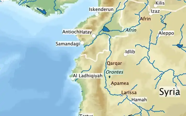
The Orontes River basin covers approximately 26,530 square kilometers, shared by Syria (67%), Turkey (25%), and Lebanon (8%). The main course spans about 404 kilometers: 38 kilometers in Lebanon, 280 kilometers in Syria, 27 kilometers along the Syrian-Turkish border, and 59 kilometers in Turkey before reaching the Mediterranean Sea near Samandag. The main tributaries, the Afrin and Karasu (Asi) Rivers, converge near Antakya (ancient Antioch).
قراءة مقترحة
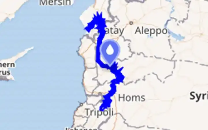
Map of the Orontes River's course in Syria
Map of the Orontes River. The white lines represent country borders, river names are italicized on a blue background, major current cities or towns are on white backgrounds, and other important places are on orange backgrounds.
2. Origin of the Orontes River's Name: Why Is It Called the "Rebellious River"?
In Arabic, "al-Asi" means "the rebellious". Unlike most regional rivers flowing west to the sea or east to the Euphrates Basin, the Orontes flows from south to north before heading west, hence its nickname. Classical sources retain the Greek name "Orontes," while in Turkish, it is called "Asi."
3. Source and Course of the Orontes River.
The river emanates from karst springs near Labweh/Hermel in northern Bekaa, Lebanon, swiftly entering Syria to flow into Lake Qattinah (Lake Homs)—an artificial reservoir created by a Roman-era dam—then passing through Homs and Hama, crossing the reclaimed Ghab plain, winding around the border, meeting the Afrin and Karasu rivers in Turkey, and emptying into the sea south of Antioch.
4. Key Characteristics of the Orontes River.
• Direction: The only permanent river in West Asia that flows north, then west to the Mediterranean Sea.
• Plains: It nourishes the Homs-Hama Passage and Ghab, Syria's agricultural heartland.
• Heritage hydraulics: The renowned Hama norias (giant wooden wheels) once lifted irrigation water into elevated channels.
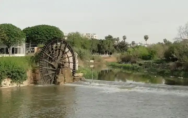
Norias on the Orontes River in Hama City, Syria
5. Hydrology of the Orontes River: Flow, Seasonality, and Figures.
• Average annual flow (entire basin): around 1,200 million cubic meters annually.
• Discharge: In Hermel (Lebanon) the average is approximately 13 cubic meters/second. At Darkush, near the Syrian-Turkish border, the average flow is about 30 cubic meters/second (approximately 949 million cubic meters/year during 1964-2011). Flows peak in winter, when spring waters bolster base flow, and decline in summer.
(Note: Some common references indicate longer main courses; the ESCWA inventory mentioned above is more conservative/technical).
6. Importance of the Orontes River as a Water Source.
Irrigation dominates the use of basin waters, with significant projects around Homs-Hama and Ghab; domestic and industrial withdrawals are concentrated in the urban corridor and Antioch. Historic and modern dams regulate water supplies (see section 8). The river supports cereal, vegetable, orchard, and cotton farming that has long made central-west Syria a breadbasket.
7. The Environment Around the Orontes River.
• Wetlands: The former Amik Lake (Hatay) and the Orontes Delta downstream of Samandag remain prime bird habitats; the delta is classified as an Important Bird Area, sheltering migrating species along the East Mediterranean flyway.
• Water quality: Good at its sources, but deteriorates downstream due to urban, agricultural, and industrial pollutants; damage from conflicts since 2011 worsened pollution, algae blooms, and infrastructure collapse.
• Marsh conversion: The Ghab marshes were drained and channelized in the mid-20th century for expanded agriculture, altering the habitat mosaic.
8. Dams on the Orontes River and Economic Investment.
• Lake Homs Dam (Qattinah): Roman stone dam (built 1938) impounds around 200 million cubic meters of water, forming a reservoir about 60 square kilometers—a major ancient reservoir still in use—supporting irrigation around Homs.
• Rastan and Mhardeh Dams (Syria): Modern river regulation and irrigation supply (profiled in ESCWA's basin inventory).
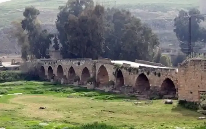
The Old Roman Bridge in Mhardeh
• Zeyzoun Dam Failure (2002): A catastrophic collapse of a dam in the Syrian Orontes basin caused floods affecting downstream Hatay, underscoring the need for joint flood control cooperation.
• "Friendship Dam" between Turkey and Syria: Inaugurated in 2011 at their border to reduce flooding, irrigate about 13,000 hectares, and generate around 16 gigawatt hours annually—the project's progress was stalled amid the Syrian war.
Economically, irrigated agriculture, hydropower, and (in peacetime) agro-product manufacturing form the river's core value chain; heritage-based tourism (see section 10) adds service income.
9. History Along the Orontes River.
• Bronze Age Geopolitics: The Battle of Kadesh (1274 BCE)—Egyptians vs. Hittites—occurred on the Orontes near Tell Nebi Mend, southwest of Homs.
• Hellenistic-Roman Urbanism: Antioch on the Orontes (modern Antakya) rose as a Seleucid then Roman/Byzantine capital. Much of the ancient city lies under Orontes' silt.
• Medieval Water Technology: Hama's norias—17 preserved wheels—elevated river water to aqueducts, a renowned feat of Islamic-era hydraulic engineering (UNESCO tentative list, 1999).
10. Tourism Around the Orontes River Basin.
• Hama Norias: A popular riverside promenade and woodcraft traditions maintain the gigantic wheels.
• Apamea: Roman colonnades stretch around the Orontes corridor.
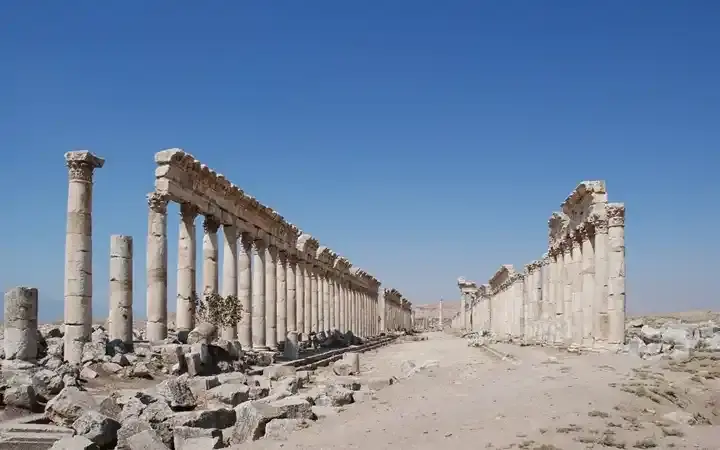
Illustration: The colonnaded cardo of Apamea over the Orontes valley
• Antioch/Antakya: Ruins, mosaics, and the cave church of St. Peter by the river; the region was heavily damaged by 2023 earthquakes, but cultural tourism remains central to recovery plans.
• Hermel and its Springs: Springs, monasteries, and rural landscapes in northern Bekaa nourish the emerging river.
11. Conflicts, Treaties, and Governance around the Orontes River.
• Lebanon-Syria Water Sharing Agreement (1994): Allocates Orontes waters originating in Lebanon (often cited at around 80 million cubic meters annually to Lebanon under certain terms), setting discharge/measurement rules; subsequent adjustments in 1997 and 2001.
• Turkey-Syria Cooperation: A 2009 memorandum envisioned the Friendship Dam and broader cooperation on water quality and drought/flood management; Syria's war stalled the basin-wide diplomacy.
• Security and Water: The Syrian conflict compromised water infrastructure and quality across the basin, politicizing flows and increasing unsupervised groundwater pumping.
12. The Future of the Orontes River.
Priorities repeatedly identified through technical and policy reviews include:
A. Rehabilitating infrastructure (intakes, wastewater treatment plants, measurement) and restoring flood control using transparent, shared data.
B. Reducing pollution (industrial pre-treatment, nutrient management) to reverse effects of eutrophication/documented health risks during the war.
C. Ecological recovery in deltas and reclaimed valleys, preserving the Orontes Delta's role as a bird migration corridor and riverine passage.
D. Equitable resource distribution and drought planning between Lebanon, Syria, and Turkey, using existing agreements as the foundation for a resilient basin-wide framework amid climate variability.
With investment and cooperation, the "rebellious" river could be harnessed again for food security, heritage tourism, and biodiversity—without repeating the environmental compromises of the 20th century.
Conclusion.
The Orontes River is more than just a river; it's a northern thread linking Lebanon's sources, Syria's heart, and Turkey's plains—connecting ancient battles, medieval engineering, modern farms, and contested diplomacy. The next chapter focuses on rebuilding war-torn systems, equitably sharing flows, and restoring ecosystems from Hermel springs to the Samandag Delta.